


The maps show the roads, the power stations, the lighthouse – but skip all the special spots where generations of Indian fishermen have moored boats or dried their silvery catch, prayed for the living and buried their dead.
So now the fishermen of Tamil Nadu are learning a whole new skill: mapping their ancient land by app – plot by precious plot – to stop industrial development from swallowing life on a lagoon.
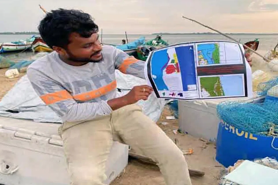
“I am just a fisherman. I knew nothing about mapping. But I had to learn this so that our livelihoods are not destroyed tomorrow,” said Mr Bharath S. Raji, whose family has trawled Pulicat Lake in Tamil Nadu for generations.
Smartphone in hand, Mr Raji navigated the sandy lakeside banks to capture places of special interest – docks, drying areas for nets, shrines to local deities.
He pointed out the holes left by the government’s latest coastal maps, blank spaces which are villages brimming with life.
With a new government zoning map three months away, Mr Raji fears his trade and whole way of life will become the next casualty of Lake Pulicat.
“We have always owned the land. But the government keeps changing the rules, not realising that our customs and livelihood here are older than their rules,” said the 33-year-old father of two.
Mr Raji and his fellow fishermen of Gunankuppam have captured the coordinates of hundreds of special places on Google Maps and other apps, none of them designated as landmarks in official government maps.
Proposals to develop the creek around Gunankuppam label the places the fishermen most cherish as “wastelands”, Mr Raji said, fearing the rapid industrialisation that is transforming much of India is about to take these away from them.
Proposals for the creek include a port and power plant, developments that could beach the hundreds of gaily painted boats that trawl the lagoon for mackerel and sea bass.
“The maps released by the Tamil Nadu coastal zone management authority have agitated the fishermen community as they are not detailed,” said Mr Ajay Anand, assistant director of fisheries in Thiruvallur district, a key member in the government agency that will determine the fate of the lake.
“So the fishing community took it upon themselves to do the survey.
“There have been many attempts of industrial encroachment but the local fisherfolk used the maps as a guide to fight them.”
The fishermen’s maps will be independently cross-checked by the fishing department, Mr Anand said. “Eventually, the government will use the maps prepared by us.”
The fishing villages around the Ennore peninsula, where the village of Gunankuppam and the lake are located, are caught between India old and new.
Around the creek, fishermen wade through sludgy waters surrounded by foundries, thermal power plants and shipyards.
“Fishermen lose their lives and livelihoods in the process of this development,” said Mr Saravanan K, a coordinator at environmental activist group Coastal Resource Centre.
“Our lands are being used to generate electricity. But we are deprived. The sea, the river – which were sources of our livelihood – are polluted in the process.”
Mr Saravanan uses GIS (geographic information system) software – which he learnt from YouTube and a friend who had studied software engineering – to map hundreds of villages in his area. Next, he recruited statewide volunteers to map the land.
Years ago, Mr Raji was among the first three villagers in his area to own a mobile phone, and would travel 20km by road just to pick up a signal with his Nokia.
Access to cheap smartphones has since skyrocketed, even in the hinterlands, with a billion smartphone users predicted across India by 2026, according to a 2022 Deloitte report.
And the fishermen look at past successes to motivate future mapping missions.
They cite appeals lodged with the National Green Tribual, a government body that enforces environmental protections, that have curbed industrial activities in protected coastal areas.
Mr Durai Mahendran, state president of the Tamil Nadu fishermen’s association, credited local mapping efforts with saving his village from a development drive that is reshaping swathes of the fragile coast.
Fisherman Dayalan D. is a convert to new technology to preserve his old way of life.
“Whenever the government comes up with a proposal to construct a road or any structure, it is easy for them to encroach on our land,” said the 39-year-old.
“But with the right documentation in the form of maps, we can prove our claims on the land.”
Thomson Reuters Founation

